Even more than 70 years after the end of the war, there are still numerous underground explosive ordnance in the Federal Republic of Germany. These pose a considerable risk to public safety (in particular life and health, freedom, property of individuals) or public order in the event of ground intervention.
In addition to various types of written sources, historical aerial photographs taken by Allied reconnaissance units are an essential medium for the reconstruction and spatial delimitation of areas potentially contaminated by ordnance.
Aerial photographs were usually taken in the run-up to attacks to identify possible targets, but also during or in the aftermath of bombings to "monitor success". In the Construction Guidelines for Explosive Ordnance Clearance (BFR KMR), aerial photographs are described as "objective "contemporary witnesses" of a region at the time of recording".
In addition to the effects of Allied bombing (explosive bomb craters, damage to buildings), they show other potentially explosive ordnance-relevant objects and structures such as various types of positions (cover holes, cover trenches, anti-aircraft positions, etc.), military facilities and areas (airfields, firing ranges, barracks, training areas) or even natural cavities in which explosive ordnance may have been placed.
In this context, unexploded bombs are characterised by a particularly high hazard potential due to the amount of explosives they contain. A certain proportion of the bombs dropped were fitted with chemical long-life detonators, which today can detonate even with minor vibrations.
For this reason, the identification and recording of bombed areas is of particular importance when analysing aerial photographs. Typical aerial photo-visible features of Allied bombing are bomb craters and damage to buildings. If detailed images of good quality are available, it is sometimes possible to identify suspected unexploded ordnance.
At Mull und Partner, aerial war photographs are analysed by qualified specialists with many years of experience. The images are usually viewed stereoscopically so that a three-dimensional image impression is created. Three-dimensional image viewing is necessary in order to avoid misinterpretations - especially when mapping suspicious points.
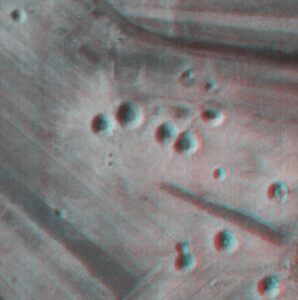
Explosive bomb craters are often clearly visible even when viewed monoscopically. Depending on the type of bomb and the subsoil, crater-like hollow shapes with diameters of often 5-13 m can be recognised in the historical aerial photographs. The funnels are often surrounded by a radial "ring" running radially outwards. This is usually soil material that was ejected during the detonation. Sometimes there are accumulations of material in the centre of the craters in the form of solid shapes reminiscent of "sand castles". The edges of the funnel are sometimes bulging like walls and are generally characterised by sharp contours.
The picture examples show several typical explosive bomb funnels. With the aid of simple red-cyan glasses, the funnels shown in the left-hand section of the image can be viewed in three dimensions.

Links to sources: Construction guidelines for explosive ordnance clearance (bfr-kmr.de)