WHAT-WE-DO: Digitalisation in the construction and environmental sector is being driven forward intensively. Spatial information forms an important basis for the processing of project-specific tasks in the business areas of the M&P Group. The collection, analysis and visualisation of geodata using modern software solutions are now an elementary part of our Group's value chain.
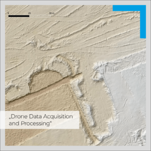
The rapidly advancing development of UAS (Unmanned Aircraft Systems) and their sensors is creating new opportunities for M&P in several business areas for the procurement of high-resolution and up-to-date geodata. Examples include the monitoring of large construction sites or the precise measurement of terrain surfaces for modelling purposes. The topic of "Drone Data Acquisition and Processing" is therefore part of our daily business. Several of our GIS and photogrammetry specialists are currently being trained for the use of UAVs weighing up to 25 kg in accordance with EU directives and can draw on around two years of flight experience in smaller weight classes.
#EngineeringForABetterTomorrow #mullundpartner #whatwedo #UAV #Drone #Lidar #Monitoring #Photogrammetry