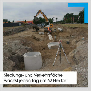
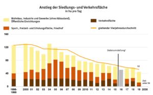
In the four-year average from 2016 to 2019, the settlement and transport area in Germany grew by an average of around 52 ha/day - as evidenced by current calculations for the "Increase in settlement and transport area" indicator. As a result, the daily increase decreased by around 4 hectares compared to the last indicator (56 ha/day in the years 2015 to 2018). In the German sustainability strategy, the German government has set the goal of reducing the average daily increase to less than 30 ha/day by 2030. By 2050, the aim is to achieve Circular economy should be aimed for. No further land should then be used for settlement and transport purposes.

The settlement and traffic area does not correspond to the "sealed area", as it also includes unsealed open and green spaces. Settlement and traffic areas include, for example, all areas directly associated with buildings, such as house and front gardens or camping sites, as well as green spaces, playgrounds and cemeteries.
In 2019, a slight increase of 2 ha/day was recorded for transport areas. This could be due to increased transport investments in existing buildings, smaller-scale construction measures and the cancellation or postponement of major new construction projects as well as the reclassification of areas in the land registers as a result of remeasurements and subsequent registrations. Traffic areas include road and path traffic areas, squares, railway traffic areas, air traffic areas and shipping traffic areas.
The settlement area hardly changed in 2019: The increase in areas for residential construction, industry and commerce (excluding mining operations and quarrying land) as well as public facilities for the production or supply of goods and services amounted to 33 hectares per day (2018: 32 hectares per day) due to the strong construction activity in the inner and outer areas of municipalities and cities. Compared to the previous year, sports, leisure and recreation areas and cemeteries each increased by 10 hectares per day in 2019.

In Germany, 14.4 % of the land area is used for settlement and transport purposes.
Land use for settlement and transport purposes has the following structure: 14.4 % of Germany's total area, corresponding to 5.1 million hectares, is used for settlement and transport purposes. Of this, 9.3 % (3.3 million hectares) is settlement land (including mining operations, opencast mining, pits and quarries) and 5.0 % (1.8 million hectares) is transport land.
In the city states, the share of settlement and transport areas was highest in Berlin (70.6 %), Hamburg (58.9 %) and Bremen (56.4 %). The proportion of settlement and transport areas in the other federal states ranged from 8.6 1TP3 tonnes in Mecklenburg-Western Pomerania to 23.7 1TP3 tonnes in North Rhine-Westphalia.
The total area of Germany is 35.8 million hectares. At 83.3 %, the vegetation area accounts for the largest share (29.8 million hectares). These areas consist mainly of agriculture with 50.7 % (18.1 million hectares) and forest areas with 29.8 % (10.7 million hectares). In contrast, only 2.3 % of Germany's surface area is covered by water (0.8 million hectares).
For comparison, the values for settlement and transport areas from 1996 to 2019:
The data basis for analyses of settlement and transport areas is the official land survey. As of the 2016 reporting year, this is based on the Official Real Estate Cadastre Information System (ALKIS). This impairs comparisons with previous years and makes it more difficult to calculate changes. The settlement and transport areas calculated after the changeover largely contain the same types of use as before. Further information on the area indicator can be found at https://www.destatis.de/DE/Methoden/Qualitaet/Qualitaetsberichte/Land-Forstwirtschaft-Fischerei/einfuehrung.html.
"Methodological notes: The indicator "Increase in settlement and transport area" is calculated as a four-year moving average. This means that it is derived from the figures for the current and the three previous reporting years. These four individual values are each calculated from the difference between the settlement and transport area of the year in question and the previous year (each determined as at 31 December) divided by 365 (leap year: 366) days.
The information on settlement and transport areas is taken from the official area statistics. This was changed for the 2016 reporting year. Until then, the settlement and transport area was determined according to the list of types of use in the Automated Property Register (ALB). Since 2016, this has been done on the basis of the Official Real Estate Cadastre Information System (ALKIS). The changeover resulted in shifts between types of use in 2016. However, the settlement and transport areas determined after the changeover largely contain the same types of use as before. In 2017 and 2018, land reclassifications were only partially included in the calculations for the indicator."
The Mull & Partner Group is committed to using its expertise to achieve the goals it has set itself: Engineering for a better tomorrow!
Links to sources etc. (optional):
https://www.destatis.de/DE/Presse/Pressemitteilungen/2021/04/PD21_209_412.html
Find out more about our work and projects and follow us: ![]()
![]()
#mullandpartner #engineeringforabettertomorrow #Buildingproject #settlementarea #trafficarea #areacirculareconomy